
Land Capability Class
Amber Anderson; Gerald Miller; Lee Burras; and Erin Smeltzly
Land Capability Classification
The soil characteristics judged in Parts I and II can be interpreted into land capability classes. The classification criteria used were developed by the USDA Natural Resources Conservation Service and are widely used in the preparation of conservation plans. Land capabilities identify the limitations and hazards of using land for agricultural purposes. The degree and type of limitations can be marked on soil maps as a basis for planning land use and management. Contiguous soils may be grouped together into one common land capability class. The land characteristics emphasized are important factors in determining whether an area of land is best suited for crops, pasture, or woodland.
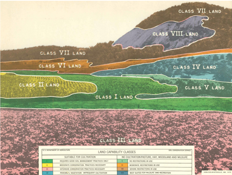
There are eight land capability classes based on the degree of hazard or limitation for use of the land. Classes I through IV are suitable for almost any use (including cropland), but with varying degrees of hazards or limitations if they are used as cropland. Class I has the broadest potential and class IV is the most restricted for use as cropland. A similar pattern applies to pasture or woodland use for classes V through VII. Class VllI land is so restricted that its use is limited to recreation, wildlife, or watershed protection purposes.
CLASS I
Class I land is suitable for nearly any use because it has no special hazards or limitations. It has soil that is deep, well to somewhat poorly drained, nearly level, medium, and moderately fine textured. These soils are productive and easy to manage. Good management is sufficient to meet their needs without any special conservation practices. Although Class I soils have no limitations that restrict their use for intensive crop production, tile drainage is often recommended for moderately well and somewhat poorly drained soils in this class. Class I land is colored green on land capability maps from the Natural Resources Conservation Service.
CLASS II
Class II is good land that can be adapted for nearly any use by taking some precautions to meet its needs. For example, land with slopes between 2-5% is likely to be in class Il-E and needs an erosion control practice such as contouring or conservation tillage. Or, land may be placed in class II-W because it needs tile drainage. Also, land occupying 0-2% slopes with an A/C soil profile (no B Horizon) and moderately coarse or coarse textures in all or part of the C horizon above 40 inches may be placed in this class. However, if coarse textures are identified above 40 inches and extend below 40 inches, these soils are generally placed in Class III. Several other hazards or limitations may cause land to be placed in class II if they are not too severe. In general, class II land has nearly the same potential as class I land except that its special needs must be met. Class II soils have some limitations that restrict their use for intensive crop production. Class II land is identified by a yellow color on land capability maps.
CLASS III
Class III is fairly good land, but needs more intensive treatment than class II land. The slope may be between 5% and 14% for sloping soils, or the soil may have clayey textures that make it difficult to work or difficult to drain. These wetter soils may be on 0-1% slopes. Droughtiness caused by shallow or sandy soils may also make soils class Ill. Normal crops of the area can be grown on class Ill land, but to control erosion, they usually must be rotated with more soil conserving crops
or have intensive practices installed such as terraces. Soils in class Ill have severe limitations that reduce the choice of plants or require special conservation practices, or both. Class Ill land is colored red on land capability maps.
CLASS IV
Class IV can be used occasionally for cropland under careful management but is better adapted for hay or pasture most of the time. The slope may be between 14-18%, or some other soil property may be equally limiting. Some land is class IV because it has already been severely eroded by previous misuse. Soils in class IV have very severe limitations that restrict the choice of plants, require very careful management, or both. Class IV land is colored blue on land capability maps.
CLASS V
Class V land is not suitable for cropland but is not likely to be damaged by pasture or woodland use. Soils in class V have little or no surface erosion hazard. Class V land is nearly level, but its use is limited by some permanent obstruction such as rock outcrops or remnant of a meandering stream channel or very poor drainage that cannot be remedied practically. The soil is suitable for growing grass or trees, and the land is well adapted for grazing or woodland use. Good management for
these uses will adequately protect these soils. Class V land is colored dark green or left white on land-use capability maps.
CLASS VI
Class VI land needs some special management, even when used for pasture woodland. Overgrazing or careless logging might cause excessive erosion. Some class VI land is so shallow that even a small amount of erosion is very detrimental to soil productivity. Some is very stony, some is very wet, and some is very drought. Lack of moisture is the most common reason for land being designated as class VI in arid and semi-arid regions. Some class VI land could be tilled, but it would
still be unsuitable for cropland because of some factor such as slopes over 18 percent. Soils in class VI have severe limitations that make them unsuited to cultivation. class VI land is colored orange on land capability maps.
CLASS VII
Class VII land has severe limitations for pasture or woodland use. The hazard may be from a slope gradient of 30-60% or some other equally serious limitation. Much class VII land is shallow and stony, but the stoniness may not be very important because there are other more severe problems. The land may be useful for grazing or forestry, but great care is required to avoid damage to the soil. Use of class VII land is restricted largely to minimal grazing, woodland, wildlife, or recreation. Class VII land is colored brown on land capability maps.
CLASS VIII
Class VIII land is unsuitable for agriculture but it may have value for recreational, wildlife, or watershed protection. Non-vegetated land such as bare rock outcrops, sand dunes, or river sandbars are included. Also, much land with sparse vegetation that should not be disturbed is in class VIll because it is extremely steep, rough, swampy, or arid. Class VIII land is colored purple on land-use capability maps.
Land Capability Subclasses
Classes II through VIll are assigned subclasses on the basis of the type of hazard or limitation restricting their use. Four subclass symbols are used to designate the problem as erosion, wetness, soil, or climate. Some soils may have two or three types of limitations but only the most severe one is used as a subclass. The subclass coming first in the list is given preference if two or more of these limitations would restrict the soil to the same capability class. The four subclasses are defined as follows:
- A. Erosion hazard or limitation related to either water or wind erosion.
- W. Wetness problem from either surface or subsurface drainage problems.
- S. Soil limitations related to unfavorable physical or chemical characteristics such as shallow depth, sandy or clayey textures, stoniness, acidity, or alkalinity.
- C. Climatic limitations such as being too cold or too dry (not used in Iowa but occurs in other places).
In soil judging, the student will classify the soil into one of the eight land capability classes on the basis of its suitability and limitations for various uses. Also, the student will assign a subclass symbol, e, w, s, or c to any soil that is not in Class I.
- Classes I through IV are suitable for almost any use, but can have varying degrees of hazards or limitations if they are used as cropland.
- Class I land is suitable for nearly any use as they are productive and easy to manage. The soil is deep, well to somewhat poorly drained, nearly level, medium, and moderately fine textured.
- Class II is good land that can be adapted for nearly any use by taking some precautions to meet its needs. These soils can have some limitations that restrict their use for intensive crop production. Slopes between 2-5% are likely to be in class Il.
- Class III is fairly good land, but the soils may have limitations that reduce the choice of plants or require special conservation practices, or both. The slope may be between 5% and 14%.
- Class IV land can be used occasionally for cropland under careful management but is better adapted for hay or pasture most of the time. The slope may be between 14-18%.
- Class V land is not suitable for cropland but is not likely to be damaged by pasture or woodland use. However, they have little to no surface erosion hazard. Class V land is nearly level, but is limited by some permanent obstruction that cannot be remedied practically.
- Class VI land needs some special management, even when used for pasture woodland. These soils have severe limitations that make them unsuited to cultivation.
- Class VII land can be shallow and stony, presenting severe limitations for pasture or woodland use. The hazard may be from a slope gradient of 30-60%. Use of class VII land is restricted largely to minimal grazing, woodland, wildlife, or recreation.
- Class VllI land is so restricted that its use is limited to recreation, wildlife, or watershed protection purposes.
- Some soils may have two or three types of limitations but only the most severe one is used as a subclass.
