
Landscape Position
Amber Anderson; Lee Burras; Gerald Miller; and Erin Smeltzly
Surface features are external soil characteristics that can be identified by observing the landscape. Landscape position and slope are surface features that influence soil development and may limit the ways in which the soil can be used.
Landscape Position
Position describes the location of the soil on the landscape and indicates whether the soil is subject a to stream flooding or potential erosion. Many different types of landscape positions can be described, but only five are included here. These five are an upland, intermittent drainageway, footslope, terrace, and flood plain.
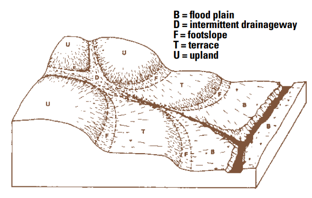
This figure shows how these five positions occur on a landscape. Contestants are encouraged to observe the landscape beyond the location of the soil pit being judged to help determine landscape position.
- B = flood plain
- D = intermittent drainageway
- F = footslope
- T = terrace
- U = upland
Upland
The upper part of the upland landscape and includes summits, shoulders, and backslopes. Summits are generally broad and flat on the top, although there can be multiple summits in one hillslope. Shoulders, much like your shoulder, begin to slope more steeply downward so a flatter part is above and a steeper part is below. Backslopes are more linear with approximately the same steepness throughout. An upland area may be subject to erosion, but it cannot receive stream deposits because it is too high to be flooded. Upland soils are normally the oldest, most strongly developed, or changed from the original parent material. Some upland soils are low in fertility, some are shallow to bedrock, and some are flat enough to need artificial drainage for highest crop productivity.
Intermittent Drainageways
Intermittent drainageway are areas where water flows from uplands and terraces during and after a rain. The water flow is wide and shallow, without following a definite channel and banks like in a stream or river. These areas become dry at other times. Permanent grass plantings are recommended to protect these drainageways from erosion.
Footslope
A footslope is a transition area of moderate slope between a relatively steep area above and a relatively flat or concave area below. The footslope is an area of accumulation of soil material that moves down from the steeper area above. The soils are usually deep and fertile. Footslopes are relatively moist sites because they receive subsurface seepage and run-on water from above in addition to normal precipitation.
Steam Terrace
A stream terrace is a remnant of a former floodplain and represents a time when the stream was at a higher level. A terrace is produced by downcutting of the stream to a level too low to flood the area any more. Terraces are absent where stream levels have not changed or where stream valley erosion has removed terraces. Some rivers have occupied various levels resulting in several sets of terraces. Each terrace contains flood deposits related to the time when the stream was at that level. Because the terrace represents an older, “abandoned” floodplain,
it tends to be quite level. Soils located on terraces are often quite fertile and productive. Some terrace soils are underlain by enough gravelly material to provide good drainage, however occasionally some terrace soils are droughty because they have gravel or sand layers at shallow depths. Some stream terraces are cut into upland slopes and contain no stream deposits within the soil profile. The location on the landscape and surface features of these terraces are consistent with terraces that contain stream deposits.
Flood Plain
Flood plain refers to the current area of flood risk near the stream; land that is relatively level and may be covered with water when the stream overflows its banks. Its width ranges from narrow strips along small streams to areas many miles wide along some major rivers. Successive floods over time may deposit several feet of alluvial material in these areas. Soil material on bottomlands often contains strata (layers), lenses, or pockets of variable textures and generally show little or no soil profile development. These soils are usually fertile except where they are too sandy or gravelly. Use and management of bottomland is often limited because of floods or high water tables.
- Landscape position and slope influence soil development and may limit the ways in which the soil can be used. The five landscape positions included here are: upland, intermittent drainageway, footslope, terrace, and flood plain.
- Uplands include summits, shoulders, and backslopes. Uplands can be subject to erosion, but they cannot receive stream deposits because they are too high to be flooded. As a result, upland soils are normally the oldest, most strongly developed, or changed from the original parent material.
- Intermittent drainageway are areas where water flows from uplands and terraces during and after a rain.
- Footslopes are often an area of accumulation of soil material that has moved down from steeper areas above. These soils are usually deep, fertile, and moist.
- A stream terrace is a remnant of a former floodplain and represents a time when the stream was at a higher level. A terrace is produced by downcutting of the stream to a level too low to flood the area any more. Soils located on terraces are often quite fertile and productive.
- Flood plains are current areas of flood risk near the stream. Floods over time may deposit several feet of alluvial material in these areas resulting in strata (layers) or pockets of variable textures with little to no soil profile development.
