
Cartography and maps
Arturo Flores and Bradley Miller
- Discuss the importance of maps for geography.
- Define the concept of geographic maps.
- Identify the different elements of a map.
Keywords: cartography, map, scale, legend, coordinates.
Cartography and map creation
Cartography is a subdiscipline of geography that graphically represents geographic data on flat surfaces. The preferred method of geography to represent spatial phenomena is with maps. A map is defined as a flat representation of spatial phenomena. Maps support visualizing data that is linked to a specific location within a geographic extent. These are easily interpreted by the users and help explain how features are spatially distributed.

Maps represent topographic features (related to the landscape) or thematic themes (quantitative or qualitative data). Topographic maps represent landforms or geographic accidents in the landscape. Thematic maps include cities and roads, land use, soil properties, and even religions distribution. It includes the absolute location of a feature (position in the Earth’s surface using coordinates) or a relative location (position using another object as reference). A map of a 10-acre farm with a pond next to a field may be useful to navigate through space locally. However, it will lack context about where that farm is located in respect to the world. On the contrary, a world map may provide the location of the farm on the Earth’s surface but will fail to be a precise navigation tool when trying to locate features, e.g., the pond.
Elements of a map
For a map to be efficient in transmitting spatial information, it has to include at least the following items:
Data. Also, the actual map. It is the flat representation of the geographic space and the spatial phenomena occurring in it and is the most important part because without it the map would not exist.
Title. The title is the first approximation of the user to the map’s content. It should provide some background on what the map represents. The title “Organic Matter Content” provides enough information to know which soil property is being mapped. However, it may not be completely clear where this field is located for someone other than the author. Hence, other guidance is required.
Coordinates and Reference Point. The coordinates help locate the geographic feature in the world. They are commonly included in the border of the map as ticks or as a grid overlaying the image. Different coordinates systems exist, and it should also be included in the map. A reference point can include a compass or arrow pointing towards the north, letting the reader situate itself better in the geographic space.
Scale. A basic concept of cartography for paper maps (fixed map scale) is that the level of detail is dictated by the map scale. For example, if we made a map of Polk County, Iowa, it would make sense to delineate the city boundaries of Des Moines. In contrast, if we made a map of the world, we would only mark the locations of cities with dots and only include the largest cities. The scale explains the relationship between the map and the real world. It describes the ratio at which an area was reduced to be fitted on the map. For example, a scale of 1:100,000 means that 1 measuring unit in the map represents 100,000 units in the real world. Such units can be meters, centimeters, feet, yards, or even kilometers and miles. Small-scale maps cover big areas like the whole world, and large-scale maps cover smaller areas like farm fields. The level of detail present in small-scale maps is significantly lower than on greater scales. Large-scale maps can go as low as 1:1, but they would not be practical. Therefore, a scale of 1:5,000 can provide a good level of detail to navigate through the streets of a town. Small scales of around 1:1,000,000 can be optimal to represent a country boundary, perhaps not for precise land management but for a broad understanding of the region’s physical geography.
Legend. A map without a legend provides little context on what the visuals represent. A legend is a reference guide to decode the symbology of the map and includes a description of what each color or icon represents. Remember to include the units when quantitative values are mapped.
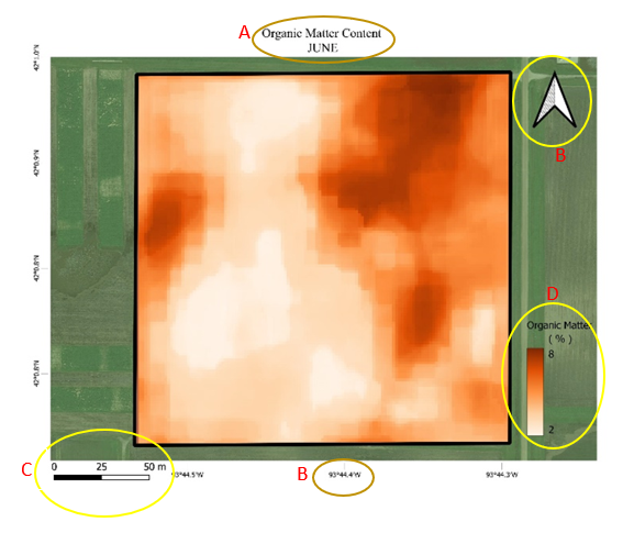
Map items: A) Title, B) Reference point and coordinates, C) Scale bar, D) Legend (Map by: Arturo F.).
- A map is the preferred tool of geography to share spatial data.
- A map should contain a title, a reference point and coordinates, the scale, and a legend for the reader to properly understand it.
- Images are not maps but can be used as base “maps” to reference and locate features in space.

.jpg)